Humminbird LakeMaster Mid-South States Edition Digital GPS Lake Maps, Micro SD Card, Version 5
- Maximize every moment of fishing when you upgrade to the unrivaled accuracy and detail of Humminbird LakeMaster mapping, which features easy-to-read contours, highlighted depth ranges, and scrollable lake lists.
- This Mid-South States Edition, Version 5 boasts more than 270 high-definition lakes and more than 385 total lakes from TX, OK, AR, LA, and MS, adding over 65 new lakes since the prior version.
- Easy-to-see shading highlights shallow-water areas within an adjustable range up to 30 feet, and depth contours and shorelines can be synchronized with the actual water levels of lakes, reservoirs, and rivers.
- LakeMaster digital maps can be used with Minn Kota i-Pilot Link (sold separately), allowing you to follow a selected depth contour line to deliver precise, automatic boat control.
- LakeMaster digital maps come on a Micro SD card (with included SD card adapter) that's compatible with all GPS-equipped HELIX, SOLIX, ONIX, and ION Series models and select 600-1100 Series models.
Retail Price:
$
97.99
Wholesale Price:
Inquire Now
This website follows the safe harbor principle. If any infringement, please inform us in time
and we will delete it in time.
About safe harbor,please click here to learn more.

After Sale Service:
1 Insurance Policy:
Click to go to the Help Center to view the Insurance Policy
2 The rules apply and summit for receive compensation
3 The conditions of accrual for amount insurance
3 The conditions of accrual for amount insurance
5 Damage to the parcel during international shipping, which resulted in damage to the goods in it
6 Loss of individual goods under international shipment
The absence individual goods in the parcel
7 Non-compliance individual goods in color, size, complications
Damage to the goods during international shipment
8 Returns Policy:
Click to go to the Help Center to view the Returns Policy

Humminbird LakeMaster Mid-South States Edition Digital GPS Lake Maps, Micro SD Card, Version 5
Humminbird LakeMaster Mid-South States Edition Digital GPS Lake Maps, Micro SD Card, Version 5
BEST SELLERS

Maximize every moment of fishing when you upgrade to the unrivaled accuracy and detail of Humminbird LakeMaster mapping, which features easy-to-read contours, highlighted depth ranges, and scrollable lake lists. LakeMaster digital maps provide the most detailed, high-definition collection of freshwater mapping in the United States, with unmatched depth contours between 1-3 feet (in high definition) or 3-5 feet (standard definition). This Mid-South States Edition, Version 5 boasts more than 270 high-definition lakes and more than 385 total lakes from TX, OK, AR, LA, and MS, adding over 65 new lakes since the prior version. New high-definition lake map data includes Brady Branch Reservoir, Caddo, DeQueen (AR), Eufaula (OK), Grand Lake of the Cherokees, Livingston, Nacodgoches, Norfork, Robert S Kerr, Skiatook, Tawakoni and more. Easy-to-see shading highlights shallow-water areas within an adjustable range up to 30 feet, and depth contours and shorelines can be synchronized with the actual water levels of lakes, reservoirs, and rivers. LakeMaster digital maps can be used with Minn Kota i-Pilot Link (sold separately), allowing you to follow a selected depth contour line to deliver precise, automatic boat control. Collected by Humminbird's own team of GIS analyst cartographers, LakeMaster high-definition maps are created from on-the-water surveys using hundreds of thousands of depth soundings, plus state-of-the-art GPS and sonar technologies. LakeMaster digital maps come on a Micro SD card (with included SD card adapter) that's compatible with all GPS-equipped HELIX, SOLIX, ONIX, and ION Series models and select 600-1100 Series models. Strictly intended for use in your Humminbird GPS unit, LakeMaster mapping cards are not PC compatible and map files could be corrupted if accessed on a computer.
From the manufacturer
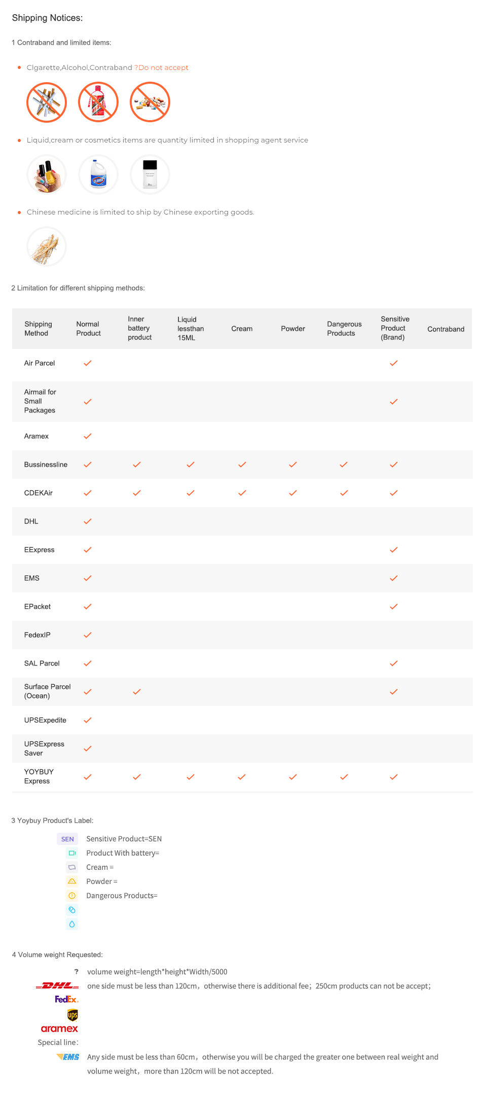
Shipping Notices:
1 Contraband and limited items:
Clgarette,Alcohol,Contraband ?Do not accept


Liquid,cream or cosmetics items are quantity limited in shopping agent service


Chinese medicine is limited to ship by Chinese exporting goods.

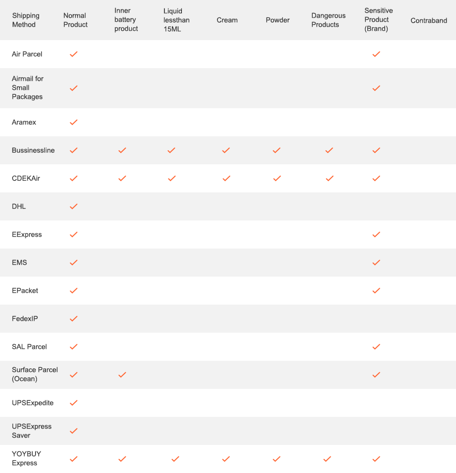
2 Limitation for different shipping methods:

3 Yoybuy Product's Label:
Sensitive Product(SEN)
Product With battery
Cream
Powder
Dangerous Products
4 Volume weight Requested:

volume weight=length*height*Width/5000

one side must be less than 120cm,otherwise there is additional fee;250cm products can not be accept;


Any side must be less than 60cm,otherwise you will be charged the greater one between real weight and volume weight,more than 120cm will be not accepted.
After Sale Service:
1 Insurance Policy: Click to go to the Help Center to view the Insurance Policy
2 The rules apply and summit for receive compensation
3 The conditions of accrual for amount insurance
3 The conditions of accrual for amount insurance
5 Damage to the parcel during international shipping, which resulted in damage to the goods in it
6 Loss of individual goods under international shipment
The absence individual goods in the parcel
7 Non-compliance individual goods in color, size, complications
Damage to the goods during international shipment
8 Returns Policy: Click to go to the Help Center to view the Returns Policy

BEST SELLERS


 Language

 Currency
Upload image to find the same item
 Drag the image here, or
Click to upload
Tips: Only jpg, jpeg, png, webp


Scan the QR code and use your phone to take a direct photo search.
×


